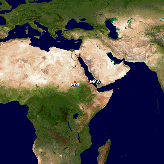
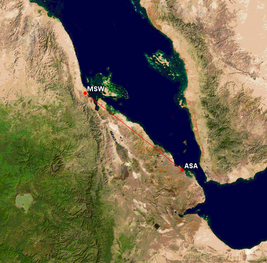
Tag Archives: Eritrea

14 June 1937

Amelia Earhart, Fred Noonan and a group of locals pose for photographs with the Electra at Assab, Eritrea, 14 June 1937. (Purdue University Libraries, Archives and Special Collections)

14 June 1937: Leg 17. From Massawa, Amelia Earhart and Fred Noonan fly their Lockheed Electra 10E, NR16020, 246 nautical miles (283 statute miles/455 kilometers) down the coast of the Red Sea to Assab, Eritrea, to prepare for the next long flight to Karachi, India. They have the aircraft serviced and fueled then await the morning.

On Tuesday, June 14, we moved down the Red Sea from Masawa to Assab to prepare for the long flight along the Arabian coast to India. Assab was nearer our objective than Masawa, offered better take-off facilities, and as well we had a greater supply of 87 Octane gasoline spotted there. Eritrea stretches along the coast of the Red Sea for 670 miles. Our course took us about half that length. Soon we left behind the mountains that bordered the coast-line and bade farewell to everything that was green. Approaching Assab the coast became terribly barren beyond description. . . .

Amelia Earhart

Amelia Earhart’s Lockheed Electra 10E, NR16020, being serviced inside a hangar at Assab, Eritrea, 14 June 1937 (Purdue University Libraries, Archives and Special Collections)
Great Circle route from Massawa to Assab, Eritrea, 246 Nautical miles (283 statute miles/455 kilometers). (Great Circle Mapper)

© 2019, Bryan R. Swopes

13 June 1937, Late

Amelia Earhart’s Lockheed Electra 10E Special, NR16020, in Africa. (Purdue University Libraries, Archives and Special Collections)

13 June 1937: Leg 16. After refueling the Lockheed Electra 10E Special at Khartoum, Anglo-Egyptian Sudan, Amelia Earhart and Fred Noonan continue on to Massawa, Eritrea, 459 miles (739 kilometers) further on.

Exactly two hundred miles out we crossed at right angles at Athara River which flows northward into the Nile. Thence the low desert roughened and rose, first into sloping sandy foothills, then mountains where green vegetation, almost the first we had seen in Africa, began to appear below us. Well into Eretrea we flew over the headwaters of a second considerable river, the Khor Baruka, which drains this highland region northward into the Red Sea. Heated air blasted up from the mountain slopes, buffering the ship unkindly. Even above 10,000 feet it was rough going. . . Massawa admits to being one of the hottest cities in the world. In the summer the thermometer often hits 120 degrees in the shade. . . On the evening of our arrival the thermometer registered 100 degrees, but that night it became comparatively cool. . . It had been a long day, what with the landmarkless desert flying, the stop at Khartoum, the rough going over the mountains the long trip down, and there was fair reason for a pilot to feel famished. (As usual I had forgotten to eat.) “Are you hungry?” an English-speaking officer asked me. “As hollow as a bamboo horse.”

Amelia Earhart

Great Circle route from Khartoum, Sudan, to Massawa, Eritrea, 395 nautical miles (454 statute miles/731 kilometers) Great Circle Mapper)

© 2019, Bryan R. Swopes